FROM THE DESK | Finding Groundwater with Thermal Imagery
Drought is the most prevalent natural disaster in South Africa.
We are a water scarce country and should be doing all that we can to better utilize and conserve this vital resource. Thermal imagery is one of the tools that we can use to improve our ability to plan for water security.
Thermal data has a variety of interesting applications but is particularly useful for geological mapping and groundwater detection (i.e. water beneath the surface).

Thermal imagery allows us to categorise land according to its groundwater potential. Large areas can effectively be narrowed down to identify high-yield target points. As a result, the number of field studies required is reduced, saving both time and cost. The success rates of new boreholes are also improved.
Thermal radiometers are mounted onto aircraft or satellites that scan and measure subtle differences in temperature at various points on the ground. The survey is best flown during dry winter periods to minimise the temperature interference of surface water and heat-radiating rocks. The general theory goes that warmer spots across a uniformly dry and cold area can be linked to the presence of (relatively warmer) water beneath the surface.
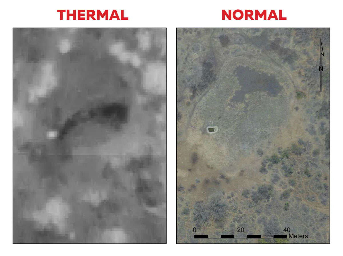
Thermal data is typically visualised as a black and white image, where:
- ‘Cold’ is shown as ‘black’: revealing (1) underground cavities (2) base flow in alluvial filled river channels (3) water bearing lineaments (4) water bearing rock contacts (5) below surface seepage and (6) deep seated ground water
- ‘Hot’ is shown as ‘white’: representing (1) dry rocks (2) areas with no ground water abstraction potential and (3) warmer surface water bodies
Thermal imagery allows us to categorise land according to its groundwater potential. Large areas can effectively be narrowed down to identify high-yield target points. As a result, the number of field studies required is reduced, saving both time and cost. The success rates of new boreholes are also improved.
Thermal radiometers are mounted onto aircraft or satellites that scan and measure subtle differences in temperature at various points on the ground. The survey is best flown during dry winter periods to minimise the temperature interference of surface water and heat-radiating rocks. The general theory goes that warmer spots across a uniformly dry and cold area can be linked to the presence of (relatively warmer) water beneath the surface.
Thermal data is typically visualised as a black and white image, where:
- ‘Cold’ is shown as ‘black’: revealing (1) underground cavities (2) base flow in alluvial filled river channels (3) water bearing lineaments (4) water bearing rock contacts (5) below surface seepage and (6) deep seated ground water
- ‘Hot’ is shown as ‘white’: representing (1) dry rocks (2) areas with no ground water abstraction potential and (3) warmer surface water bodies

During 2015, SATPLAN ALPHA assisted the Bakgatla-ba-Kgafela Traditional Authority (BBKTA) with a wall-to-wall thermal survey of their tribal area.
The BBKTA are located in the Pilanesburg region of the North West Province in South Africa. This is a very dry region of the country that fringes Botswana and the hinterlands of the Kalahari Desert. Rain is precious in these parts, to the extent that the nearby currency of Botswana is called the ‘Pula’ (directly translated: ‘Rain’).

An area of approx 110 000 hectares was flown for the survey covering all 32 villages and land holdings of the tribal area.
The resulting thermal imagery dataset is an important component of the BBKTA’s spatial data inventory for development planning. Moving forward the data will provide valuable scientific input for developing a regional water security strategy. New agricultural projects can also be supported through improved water viability. Water is critical to grow local economies and alleviate poverty in South Africa. Thermal imagery can help us get there.
Where there is data there is hope!
